
Two Rivers Lodge is an American,family owned,nostalgic,Mom & Pop Motel on the on the Oconaluftee and Tuckaseegee Rivers. We provide a relaxing casual environment from our homey rooms,deep porches, and outdoor spaces to our large pool and kiddy pool. This is the perfect base camp for your motorcycle group,sports car club,family reunion,river adventure or hiking trip with easy access and central location to all of the best roads and attractions. We provide memorable experiences. Great Reviews !

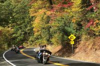
Marion to Tazewell VA-32 Miles-Over 300 Curves
The BackoftheDragon16.com motorcycle ride is thirty-two miles on with over three hundred plus curves switchbacks, slaloms, hairpins and turns. The BackoftheDragon16.com is a motorcyclist and car enthusiast road with breathtaking views of the surrounding Virginia’s scenic mountain landscapes. The ride starts from Hungry Mother State Park north of Marion, Virginia on route 16 and ends 32 miles later at Tazewell Virginia through the heart of Southern Appalachia, crossing the Big Walker, Brushy and Clinch Mountains.
Get your souvenirs here… T-shirts, patches, pins, and more at motorcycleridershop.com
The Snake 421 is also known as “The Best of the Snake,” and is a sample of some of the best of the combination of roads that make up the rides known collectively as “The Snake”. The series of roads that make up The Snake travels 112 miles and is a heavily traveled Motorcycle and Sport Car Ride. The Snake 421, aka The Best of the Snake, is a really nice 37 mile section of The Snake, offering 489 curves while crossing 3 mountains and traveling through one beautiful valley. It travels through Johnson County, Tennessee and Washington County, Virginia. It is considered by many as one of America’s favorite chartered Motorcycle and Sport Car Rides. This ride has something for everyone from new riders to experienced riders. This is a ride you will want to experience.

If you’re intrigued by the idea of traveling eastern Tennessee’s patchwork of two-lane roads, plan to take on “The Devil’s Triangle” this season. This memorable 72-mile route, winding through Tennessee’s Cumberland Plateau, is meant for experienced riders ready for the region’s simply maintained roads and challenges around every curve.
If you enjoy traveling gently curving rural roads dotted with houses, farm scenery, and random ATV’s, you’ll find those vistas here. On the other hand, you’ll encounter plenty of switchbacks and twisted turns that closely resemble The Dragon’s challenges.
As an added bonus, The Devil’s Triangle throws in roadside rock-filled gullies, impressive rocky cliffs, mangled guardrails, and rutted roadways. Keep a watchful eye for trucks, as some parts of the route don’t leave much room for pull-offs and other evasive maneuvers. Finally, let’s not forget the route’s notorious climbs – including at least one section with a 1600-foot change in just 1.5 miles.
Finally, you won’t find competing tourist attractions along The Devil’s Triangle route. However, you will encounter the now-closed Brushy Mountain State Penitentiary, a notorious regional facility that opened in 1896 and closed in 2009. This maximum-security prison, located in a nondescript two-story building, held the “worst of the worst” criminals during its lifetime. Today, travelers are invited to tour the prison, visit the facility’s museum, and buy some “End of the Line” Tennessee moonshine (which is actually distilled and bottled onsite). Paranormal tours are also available – if you dare.
If you want to ride the same roads as the Prohibition Era moonshiners, put the “Moonshiner 28” run on your touring calendar. This 103-mile route begins at US 129 at the “Tail of the Dragon,” and meanders southeastward through North Carolina and into upstate South Carolina. In contrast to The Dragon’s non-stop twists and turns, Moonshiner 28 offers a 55-mph speed limit for the majority of your ride.
As you cruise along, you’ll encounter a nice mix of twists and turns, sweeping arcs, and memorable scenery. Shortly after you begin the trip, for example, you’ll arrive at the massive Fontana Dam. Here, you’ll enjoy a bird’s eye view of beautiful Fontana Lake and Great Smoky Mountains National Park.
Heading toward Highlands in southern North Carolina, you’ll see the notable Cullasaja Falls that cascades downward in a 250-foot drop. Further along, you’ll encounter Dry Falls, a popular destination for travelers of all ages. Enjoy an easy hike from the parking lot, and wind your way downward to the impressive 75-foot waterfall. For an experience you won’t forget, stand under the roaring falls and take in the sights and sounds.
Finally, Moonshiner 28 takes you on a leisurely trek through Georgia and South Carolina, with the quiet town of Walhalla marking the end of your trip. Throughout your ride, you’ll find basic to super-nice accommodations and an enticing assortment of antique and craft shops. If you’re looking for a hearty meal to fuel your travels, you’ll find plenty of options to suite your tastes.

Lake View Drive, more commonly known as the “Road to Nowhere”, begins just outside Bryson City and runs approximately 6.5 miles inside the Great Smoky Mountains National Park. Its construction is like that of the Blue Ridge Parkway with many gentle curves and some beautiful vistas. Its destination is, literally, nowhere. The road was never completed after the construction of Fontana Dam, and it ends at the entrance to a tunnel. It’s a fun, short motorcycle ride that leads to some beautiful hiking trails. One set of trails is reached by walking approximately 1200 ft. through the tunnel. Another trail, Noland Creek, begins at a trailhead just before the end of the road. There is ample parking at the trailhead and at the tunnel.

Hoppy Trout Brewing Co. began as an obsession with home brewing. Years of experimentation with ingredients and development of recipes prepared Brewmaster, Tom Rodeck, for brewing on a commercial scale. Hoppy Trout is a community brewery that mainely brews beer for consumption in the taproom, however this specialty, small batch beer can also be found on tap in a select few restaurants and bottle shops. Over the years Hoppy Trout beers have continued to garner accolades for their superb flavors, unique beers, and one-of-a-kind styles that set it apart from other breweries .
In addition to its distinguished beer Hoppy Trout’s kitchen features a custom made Sicilian style brick oven that bakes unique and delicious pizzas. The secret to this savory pizza is twofold-Hoppy Trout makes fresh homemade pizza dough daily and uses only fresh ingredients. In addition, customers will delight in savory panini sandwiches, fresh salads, and an array of diverse and delectable appetizers.
Hoppy Trout is not only a brewery and restaurant, but a place where locals and visitors alike come together for community and fun. Events during the week include a weekly Trivia Night where patrons test their wits and compete for prizes every Wednesday at 6:30pm. On Thursdays, the beer cascades from the taps a reduced rate of $4 per serving all day long! Other events such as comedy shows, home brewing competitions, and holiday parties makes Hoppy Trout a great place to visit for the whole family.
Down-home pit stop dispensing a range of Southern classics & BBQ in cozy, rustic quarters.
In 2004, the addition of the Dragon’s Den Grill was added to the resort allowing 65 guests to sit, relax, and have a great meal. Four years later, the addition of the beer on tap was installed, so one can enjoy a cold beer with their meal if desired. Three TVs set on weather, news, & SPEED Networks are positioned around the Grill to keep you updated on current conditions & race day shouting at the tv. The grill is air conditioned for our hot summer days & heated for our cooler early spring and late fall travelers. We offer 6 speciality burgers (don’t worry regulars, you can still have our original Dragon burger too!), a daily deli, homemade desserts, & much more. We also offer window bar seating overlooking the parking lot and Wheelie hill, which are the best seats in the grill!! Come check it out!!
We serve breakfast starting at 8AM every morning, considered by many to be the best there is in the area. Lunch starts by 11AM, serving our famous dragon burger, chicken, BBQ, sandwiches, and many more items available on the menu, along with daily specials.
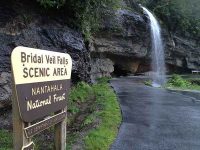
Tapoco is situated on 120 acres in the lush mountain region of the Nantahala National Forest on the banks of the cascading Cheoah River. Adventures like hiking, rafting, kayaking, fishing, mountain biking, and winding roads are plentiful. After your day of adventure, experience sanctuary in one of our historic rooms with modern conveniences. Later on, enjoy riverside dining or an evening by the fire pits.
One of the most visited tourist attraction near Robbinsville, NC by road enthusiasts, nature photographers or anybody who is just seeking for a relaxing ride and nature-inspired adventures. Cherohala Skyway is known for its spectacular scenic overlooks, beautiful mountain views, world class hiking trails and pristine waterfalls. It was also featured in Discovery Channel’s Top 10 Motorcycle Rides in North America.
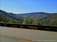
The Cherohala Skyway is a 43-mile (69 km) National Scenic Byway and National Forest Scenic Byway that connects Tellico Plains, Tennessee, to Robbinsville, North Carolina in the southeastern United States. Its name is a portmanteau of Cherokee and Nantahala, the two national forests through which it passes. Along with multiple vistas and overlooks, the skyway provides easy vehicular access to various protected and recreational areas of the Unicoi Mountains, including the Citico Creek Wilderness, the Bald River Gorge Wilderness and old growth trees in the interior of Joyce Kilmer Memorial Forest.
Mile High Legend – 43 mile National Scenic Byway from Robbinsville NC to Tellico Plains TN
The Cherohala Skyway was completed in the fall of 1996 after planning and construction for some thirty-four years. It was North Carolina’s most expensive scenic highway carrying a price tag of $100,000,000. It winds up and over 5,400 foot mountains for 18 miles in North Carolina and descends another 23 miles into the deeply forested back country of Tennessee. The Skyway is well known in motorcycling and sports car circles for its long, sweeping corners and breathtaking scenic views.
It could be extremely dangerous at night and in the winter months. There are no facilities other than a couple of restrooms for the entire 41 miles so make sure you have enough gas to make the crossing. There are also picnic tables with mile-high views along the way that visitors can enjoy.
Vehicles can turn around at one of the overlooks or continue down the ridge in Tennessee. At the state line, the descent starts into the Tellico River basin. If continued into Tennessee, take a detour to Bald River Falls on paved Forest Service Road 210 to see the 100-ft. waterfall from the car (or motorcycle).
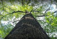
Joyce Kilmer Memorial Forest is part of the Nantahala National Forest, approximately 3,800 acre tract of publicly owned virgin forest in Graham County, NC, near Robbinsville as a living memorial to the writer/poet Joyce Kilmer. Veterans of the Foreign Wars asked the government to set aside a fitting stand of trees to serve as a living memorial to Joyce Kilmer, who was killed in action during World War I. Although Kilmer was both a soldier and a poet, he is most remembered for his poetry about common, beautiful things in nature
One of the largest contiguous tracts of old growth forest in the Eastern United States, the area is administered by the U. S. Forest Service. The memorial is a rare example of old growth cove hardwood forest, a diverse type unique to the Appalachian Mountains. In 1975 the memorial forest was joined with a much larger tract of the Nantahala National Forest to become part of the Joyce Kilmer-Slickrock Wilderness.
Due to a devastating disease of the American chestnut tree that caused a rapid, widespread die-off of the once plentiful tree from its historic range in the Eastern United States, the American chestnut, once the dominant tree of the forest, was affected by the chestnut blight. Although the last of the Kilmer chestnuts had probably died by the late 1930s, their wood is so rot-resistant that remnants of the massive logs and stumps are still visible.
Another more recent loss is that of the giant hemlocks due to an infestation of an exotic insect, the hemlock woolly adelgid. For safety of visitors from a falling limb or tree, Forest Service managers decided to bring down dead trees near the memorial trail in a way they believed would mimic natural blowdown. In November 2010, the Forest Service blew up the trees with explosives, making the lower loop trail much lighter and drier.
The best way to enjoy the impressive memorial forest is by doing the easy 2-mile hike to see the majestic Trees such as Sycamore, Beech, Basswood, Red and White Oaks and Hemlock. Some of the trees are over 400 years old and the oldest Yellow-Poplars are more than 20 ft (6.1 m) in circumference and stand 100 ft (30 m) tall. Aside from the trees there are also other variety of shrubs, vines, ferns, mosses and other plants to see. This popular family hiking destination features an easy two-mile, figure-eight trail and has two loops: the 1-1/4 miles lower loop passes the Joyce Kilmer Memorial plaque, and the upper ¾ mile loop swings through Poplar Cove, a grove of the largest trees.
The trailhead parking area has a flush toilet and picnic tables. No camping or overnight parking is allowed.
The only way to see the impressive memorial forest is on foot. The figure-eight Joyce Kilmer National Recreation Trail covers two miles and has two loops: the 1.25-mile lower loop passes the Joyce Kilmer Memorial plaque, and the upper 0.75-mile loop swings though Popular Cove – a grove of the forest’s largest trees. The trailhead parking area has a flush toilet and picnic tables. No camping or overnight parking is allowed.
Located about 15 miles from Robbinsville. Take Highway 129 North for 1½ miles to the junction with Highway 143 West (Massey Branch Road). Turn left on Highway 143 and travel approx 4 miles to a stop sign/T intersection. Turn right and drive for approx 7.3 miles and bear to the right at the junction of Santeetlah Gap and the Cherohala Skyway. Continue for another 2½ miles to the entrance of the Joyce Kilmer Memorial Forest on your left.

Tourist attraction in Swain County, North Carolina
Ok so this wasn’t on MY bucket list .. but was on my husband’s so it was on our anniversary trip to-do list! And it really didn’t disappoint ether! 318 turns in 11 miles with steep drops and no guard rails! This road is not for inexperienced drivers… But if you drive slow and take the turns carefully it is a pretty amazing experience. There are some cool shops just before you drive into TN that mark the beginning of your drive, and they have memorabilia and stuff. Look for the dragon statue to your left– he is all made of metal! Just beware.. it isn’t for people who don’t like heights or who can’t navigate turns well.
318 turns in 11 miles, one of if not the best drive I’ve ever been on! If you love curvy, challenging mountain roads and amazing views, this is the route for you! I drove through completely by accident on my way to the Foothills Parkway but I’ve always wanted to drive the tail of the dragon and I got to its something you must do if in the area!
The Dragon is popular and internationally famous destination for motorcycle and sports car enthusiasts since 1981. Known as America’s number 1 motorcycle and sports car road, famous for its 318 curves in 11 miles (18 km). The road earned its name from its curves being said to resemble a dragons tail. The stretch bears the street name Tapoco Road in North Carolina and Calderwood Highway in Tennessee and is signed entirely by US 129 (hidden SR 115).
Deals Gap, also known as Tail of the Dragon, is a portion of U.S. Route 129 in Blount County, Tennessee, situated in a gap in Swain County, North Carolina, United States. It was publicized as one of the most scenic drives in USA. This road is appealing to those who are looking for adrenaline rush and excitement. With hundreds of blind curves, long blind crests, and high degrees of camber, this road presents plenty of opportunities to leave the pavement both laterally, and longitudinally, and will provide a challenge even for the most seasoned drivers/bikers.
The Great Smoky Mountains and Cherokee National Forest border the Dragon, there is no development along the 11-mile stretch, this adds to safety as well as natural beauty. The Dragon stretch of US 129 is double-lined as no passing (there are pull offs you can use to allow tailgaters to get ahead of you.) There are also pull-off points along the route for scenic overlooks. The road is certainly breathtaking, but has a fearsome reputation, speed limit was posted at 30 mph in 2002 and still in effect today. Trucks are also prohibited to enter the road due to previous accidents and incidents involving trucks and semi-tractor.
The best time to drive this road is between March and November. Winter months can be hard to predict. The weather on this zone is harsh and highly unpredictable and it does not take much time for the bright sun shine to change over to moderate to heavy snow fall. This road had a reputation for being extremely dangerous because of unpredictable snowstorms and blizzards, and driving under these conditions, can be challenging. This road is not for the faint hearted, but if you are looking for a little excitement and adrenaline pumping journey, dont miss this one.
This is a beautiful campground. The owners are helpful . It is the type of mountain setting you look for and it delivers with a creek, trees and a river.
Such a nice place to stay. Each site is next to the river or the creek that runs through the property. Looked like every site had shade as well. The family works hard to keep the place well maintained and clean.
At the risk of losing the benefits of having this campground nearly to ourselves, we feel compelled to give the new owners the highest accolades. They are extremely responsive and have really spiffed things up. The campground itself is quaint and lovely, with a good size creek running through it and bordering the Valley River on one side. It is easy access just off Hwy. 74 outside of Marble (between Murphy and Andrews).
We love this little gem of a campground!
Turkey Creek, a small babbling brook, meanders through our quiet, little cove on its way to the confluence of the Nantahala and Little Tennessee Rivers, which is just a short hike through a southern Appalachian hardwood forest. A wide variety of vegetation ensures a continual display of color throughout the year.
At the office you’ll find firewood and ice for sale. Next to the office is the game room which has a foosball table and a pool table (closed while social distancing measures are in place). A sanitary dumping station is next to the office for travel trailers and recreational vehicles, there are no sewer hook-ups. Below the office is the beautiful, tiled bathhouse with hot showers. There’s a small, coin-op laundry room that also has double sinks for washing dishes.
TCC’s park like setting has the following. Most campsites have 20 amp electrical service and water. All sites have picnic tables and fireplaces. Most of the creek sites have 10′ x 12′ raised tent pads, some are 12′ x 12′ .
Most sites are shaded at least part of the day.
There are 9 sites with water and 30 amp service, We can take up to 30ft rigs, including tongues, on travel trailers due to the tight turns in our roadways.
Free WIFI is available around the office/deck/bathhouse complex. WIFI is limited so we ask you to read our policy and comply.
It is our goal to provide a comfortable, peaceful, restorative and joyful experiences. At The Heart Center, we invite you to reclaim your own inner peace, physical and emotional harmony, innate wisdom and power, strengthen your personal relationships, and rediscover your unique connection to nature and the Divine.
Nelson’s Nantahala Hideaway is nestled in the heart of the Nantahala forest at Topton, NC. Fidely Nelson settled our family here in the late 1800’s and we invite you to experience true Southern Appalachian hospitality at our campground and cabins surrounded by hiking, trout fishing, whitewater rafting, canoeing, kayaking, bicycling, horseback riding and more. After an exciting stay in the Nantahala gorge… enjoy rustic living and spend a relaxing evening around your own private campfire. Walk in the footsteps of the great Cherokee Chiefs and discover “what Fidely did” in the foothills of the Great Smokey Mountains.
Stay at one of the oldest private campgrounds in Western North Carolina. 80 plus years of peaceful relaxation. Tucked up in a valley at 2,000 ft. above sea level you will be next to a beautiful state stock Panther Creek that falls into Lake Fontana. Catch Rainbow trout , Brook trout, and Brown trout right from your camp site. Where the star’s are bigger and brighter because you are no where near city lights. No highway noise, just creek and crickets. Hiking trails from campground.
Feel the peace of God’s great Earthly Creation as your Cares float down the creek. Off the beaten Path, our valley is home to Panther Creek. We can’t wait to meet you!
We are just minutes away from some of the best things to do in the smokies. Fishing, water skiing and tubing in Lake Fontana, fast cars in Deal’s Gap and Tail of the Dragon, Whitewater rafting in the Nantahala river, The Smokey Mountain National Park, Deep creek tubing, Shopping in Bryson City, The Smokey Mountain Railroad, Joyce Kilmer Forest, Cherokee NC, Harrah’s Cherokee Casino, Tsali Mountain Bike recreational area and The Appalachian Trail.
No entries were found.